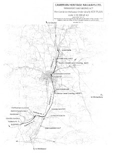
Glynn's Picture Map, published earlier on the blog was intended to give an overview of the Weston Section but perhaps a bit more explanation is needed on the overall CHR project.
The TWAO application map details the relative position of the various parts. The ultimate intention is to have all parts connected and operational. Here is the basic layout of the CHR project with the component sections marked up.
The larger version is available here
The Weston section forms part of Railway 2 and this will eventually link the two CHR operational sites at Oswestry and Llynclys. Timing for the completion of Railway 2 will depend on many things but we are committed to the goal of linking once again Oswestry with Llynclys.
If you would like to see a more detailed and annotated map take a look here and by clicking on the box at the top left of the map you can get to a very large scale version. Please note that viewing the large scale version on a tablet or phone you will at first only see what appears to be a blank page, you need to scroll across or down so that the image comes in to view.
Whilst this blog is looking mainly at the section from Oswestry to Weston Wharf there is much going on at the other sites. Llynclys station has been repainted whilst Tony, Trevor and crew continue their excellent work on the coach fleet. Pop in to take a ride and see what is going on. Here is a picture courtesy of the CHR Facebook page showing the freshly painted fence.
The station at Gobowen has been secured and all of the land required to create a functional terminal station is now available. This forms part of Railway 1 on the TWAO map.
Hopefully June should see the start of digging under the propped bridge allow us to push on to Weston.
Until next time


No comments:
Post a Comment